Ground-truthing Wildfires in the Simpson Desert, Australia
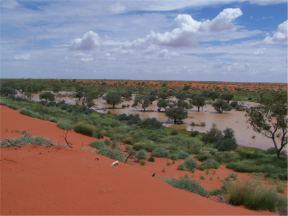
Wildfires burn large tracts of the Simpson Desert every few years and lead to highly damaging effects on native wildlife. The fires remove shelter for native animals, thus exposing them to predation from invasive cats and foxes. If reliable fire maps are available, this makes it possible to predict where future fires are most likely to occur and also to manage the effects of invasive predators before they have been able to inflict damage on native animals. At present, satellite imagery can give a rough idea of the spatial distribution of fires, but imagery often confuses open habitats (e.g. claypans, open dune tops) unless it is ground-truthed. This project has completed some ground-truthing in the north-eastern part of the Simpson Desert following intense fires in early 2012, but has not been able to extend mapping to the desert’s southern regions. The participation of Adventure Scientists has been invaluable in contributing to the ground-truthing of a large region of the Simpson Desert that is generally not very accessible, and thus in helping with the future management of a very large part of arid Australia.
How can volunteers participate?
Volunteers can assist enormously by doing two things while on their route through the desert: 1) recording GPS points at any and all boundaries between burnt and unburnt vegetation, and boundaries between different habitats (the main habitats would be clay pans, open plains, water bodies, spinifex grassland, gidgee or other woodland, dune crests); 2) photographing each boundary where a GPS point is taken. For example, if a team crosses a boundary between burnt and unburnt spinifex grassland, a GPS point would be taken at the boundary and a photograph taken at the same point looking along that boundary. This allows us retrospectively to confirm that the boundary was between burnt and unburnt spinifex (or claypan and woodland, dune crest and dune side etc). Each photo must be tagged so that each GPS point can later be matched to the relevant photograph.
How will this data be used?
Our partners will use the data to compile detailed and reliable fire maps for the Simpson Desert. Although the team’s route will cover just part of the desert’s southern extent, the data collected will allow ground-truthing that should allow much broader and reliable interpolation of fire extent from satellite mapping. The maps should in turn allow us to identify habitats or other features that provide refuge for native fauna during wildfires, predict where future fires will occur (recently burnt habitats will usually not burn again for 25 years), and allow management efforts to be allocated more strategically than is possible at present. Fire maps will be published in the scientific literature and also provided to conservation managers in the Simpson Desert region.
What else should volunteers know?
The Simpson Desert – even in winter – can be a deceptively dehydrating place! Among other safety precautions, travelers need to ensure regular fluid intake.
To Participate in this Study Please Tell Us About Your Expedition